Housing Solutions using GIS Techniques

Our Experience

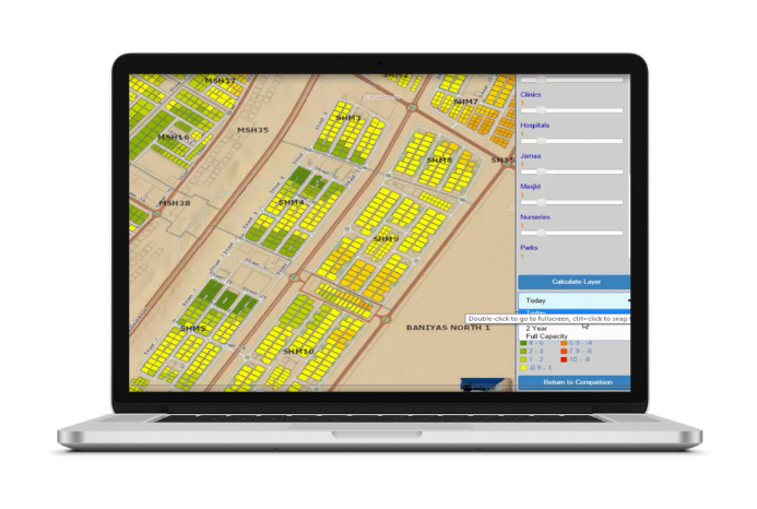
GeoLinks has tremendous experience and subject matter experts in housing and urban planning projects, the company worked closely with the housing authorities in UAE to developed the road map for spatial analysis and built different valuable applications of geographic information systems (GIS) and spatial analysis by experienced and professional team that understanding housing needs, addressing broader issues of urban planning and community development.


GeoLinks team improved the access to information, services related to housing, and provided quick answers for the decision makers and different level of users. in additional to that GeoLinks offered a vision of Housing Authorities as an important player in providing housing data to federal initiatives towards a spatial data infrastructure for the nation.

GeoLinks Success Stories

The Challenge

Abu Dhabi Housing Authority has different sources of spatial and non-spatial data and not displayed together in one platform. Abu Dhabi Housing Authority decided to build and maintain a centralized spatial database.


GeoLinks was hired by Abu Dhabi Housing Authority to develop the GIS road map and build the first web mapping application to display the existing housing projects, community facility location in additional to loans and grants distribution.

1. Portal for ArcGIS Configuration and Deployment

Allows users to search, view and interrogate data held on the Central Geodatabase, and connect to web services delivered by other entities.

2. Completing Emirati Communities

Shows status of loans and grants in Abu Dhabi and gives information to decision makers dynamically without the need to wait for a report in a dashboard style.

3. Decision Support Model

Customized Web Mapping Application models gaps in community facility provision and assessment of existing Emirati community and the facilities available to support decisions on CF future needs and help Abu Dhabi Housing Authority to Priorities the Loans and Land grants in additional to enables proactivity rather than reactivity.

4. Operations Dashboard

GIS Dashboard gives managers an overview of all supply and demand for house and land plots as well allowing more focused decision making to be undertaken and a quick and brief summary on the status of the status of Abu Dhabi Housing Authority’s current inventory. The dashboard gives the capability of projecting the effects if a maintenance supply occurred. Thus, allowing more focused decision making to be undertaken.

5. Planning Tools

Customized Web Application developed to automatically plan House maintenance for the upcoming years taking in consideration maintenance priority and to give an overview about the maintenance situation for Abu Dhabi Housing Authority Inventory

GeoLinks Services for Abu Dhabi Housing Authority

The following services were provided by GeoLinks to guarantee successful implementation of the project.

GIS Assessment and Planning

Database Design and Implementation

System Design and Implementation

Application Programming

Outreach and Communication

Training / Capacity Building

Automation of Maintenance Planning

Staff Augmentation

The Challenge

Mohammed Bin Rashid Housing Establishment has different sources of spatial and non-spatial data, and they have different groups and users with different roles and authorization to view the data.


GeoLinks was hired by Mohammed Bin Rashid Housing Establishment to develop a GIS a customized Web Application to display the existing housing projects, loans and grants distribution, in additional to GIS statistical dashboard to analyse and display spatial and non-spatial data.

1. Mohammed Bin Rashid Housing Est. Portal

The GIS PORTAL is a web application deployed over the GIS Server of Mohammed Bin Rashid Housing Est., the application uses the latest ESRI technology for data representation and querying and provide summary, reports and charts based on accessing real time data.

2. Operations Dashboard

The views allow senior management instant access to a range of spatial and non-spatial datasets from across the organization, together with customized widgets, which give them an overview of the performance of the business, or specific measures, as specified by senior management. The implementation of enterprise GIS project included the deployment of geospatial infrastructure and development of a spatial data model to spatially enable the two main databases that Mohammed Bin Rashid Housing Est use on a daily basis – the Properties and Applicant Database and the Projects Database.

Close Bitnami banner
Bitnami